|
|
| Home-->Travel Stories-->Copperstate 2000 Page 1 |
|
SITE CONTENTS
Please send your comments and suggestions to: Copyright
© 2008 by | Links
on this page: Introduction Planning Day 1 Day 2 |
|
|
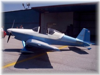
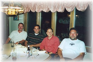
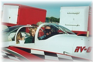
Introduction In August 1993, a dream was born with the arrival of my RV-6 empennage kit. That dream was to build another airplane (my first airplane was Long-EZ N2517C) and then use it to travel the country, perhaps visit all 50 states. Following the first flight of N417G in June 2000, I began contemplating my first long range trip to begin the fulfillment of my dream. I attended AirVenture 2000 but Indianapolis to Oshkosh was only a two-hour trip. (Ah, the beauty of a fast airplane.) That didn’t really scratch the itch, so to speak. I needed something just a little more challenging and exciting. While registering my airplane at the Homebuilt booth at AirVenture, I spied a pile of handouts for the Copperstate EAA Fly-in, held in Mesa, Arizona in October. The wheels in my brain started turning immediately. Visions of sun, golf, Sedona, Grand Canyon, and cobalt blue skies danced through my mind. Besides, while vacationing in Sedona last year, I told my wife that I would land my airplane at the Sedona airport one day. This, I said to myself, would make an excellent trip. With that settled, all I needed were a few buddies to share in the fun. I contacted my fellow RV builders/flyers in Central Indiana though The Indianapolis First Air Force and found three other flyers that shared a dream similar to my own. Glen David (left), his wife and daughter would go in Glen’s 3-place RV-6. They had family in Phoenix and Southern New Mexico that they hadn’t seen in awhile. Bob Japundza (second from left) would bring his new bird, a sharp RV-6, and a yet to be named accomplice. Bob is a fellow computer consultant who finished his airplane just weeks behind me. Clay Smith (third from left) would bring his daughter in his brand new RV-4. Clay is a tried and true air traveler. Last summer, he cruised around the country with a sleeping bag in his trusty Luscombe to build up his cross-country hours prepping for his Commercial license. I (right) would bring my 18 year old son, Alex.
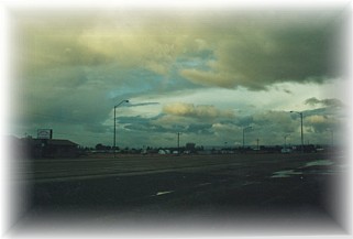
Since this “little” trip would involve significant distances and flight hours, many of the wives…..okay, MY wife anyway………..was concerned and just a tad bit apprehensive……okay, okay, she was REAL apprehensive. A cookout with the flyers and our wives was in order to make acquaintances and allow everyone the chance to participate in the planning. However, even before we could hold the cookout, problems developed. While flying the final few hours off of his new bird, the engine on Clay Smith’s RV-4 spit out a valve seat in cylinder #1. Fortunately, this happened to Clay while he was on the ground during a fuel stop. Unfortunately, his bird was going to be down for more than a month for a cylinder rebuild and a thorough internal checkout. Then, just days later, Bob Japundza decided to remove that pesky taxi light in front of his hangar with his new Hartzell prop. Although he only clipped the glass bulb with one blade, it was enough to require a prop shop to fix. Frantic searches failed to find a shop that could turn the prop around in time for the trip, so Bob was bummed, as were Glen and me. We hoped that this was not a portend of things to come. To help plan our trips, we made extensive use of three Web sites. First, www.airnav.com helped to layout the great circle route and helped to check fuel prices. Second, I used www.echarts.cc to order all my sectionals, WACs, and terminal charts. Third, I used www.aeroplanner.com to fill in the details and to print easy to use trip tickets. Our planned westward route would be Indianapolis, IN to Marshall, MO to Liberal, KS to Albuquerque, NM to Mesa, AZ for a total of 1290 nautical miles. Weather would determine the actual course taken, our fuel stops, and where we would spend the night. Our departure was set for Wednesday, October 11. My wife wasn’t any less apprehensive after the planning session. (Fear of heights will do that to you.) However, she knows me well enough to know that I’d be as safe and careful as possible. In short, she gave me permission to go. Whew! The weather reports looked very good over most of our course. Clear skies with strong winds dominated the Midwest and Plains. It was raining in New Mexico but it was anticipated to be scattered by the evening. Arizona was clear. We were a go for launch! My son Alex and I loaded about 50 lbs of baggage into the back of our RV-6 and we pushed her out of the hanger just as the sun was cresting the nearby corn fields. Our anticipation was palpable as we fired up our bird and departed Franklin Flying Field (3FK) for Eagle Creek (EYE) to pick up Glen, his wife Jacque and their daughter Jenny. Glen’s “3-place” RV-6 is really a standard RV-6 with a child seat bolted to the luggage floor in the back. Glen is an AP and AI for United Airlines so he has access to material and services the rest of us only dream about. With his daughter on board, that meant that Glen had to ship some of his baggage ahead of him to relatives in Phoenix.
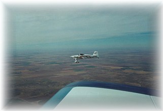
We passed directly over downtown Indianapolis just as the morning rush hour was beginning. I smiled to myself as I spied the traffic backup on the freeway, knowing that I was free, if but temporarily, from its grasp. I circled Eagle Creek as Glen and his RV-6 departed. We met up, tuned in 122.75 MHz and pointed our birds toward the western horizon. Prior
to departure, I had identified checkpoints along our intended course line,
one about every 30 minutes or so. Although
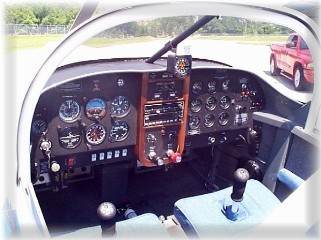
both Glen and I were navigating with GPS, I wanted to teach my son about
navigating “the old way”. Not
only would it teach him a practical lesson on using Trigonometry and
Physics, it would also provide important backup to our GPS.
I learned a very important lesson on my trip to AirVenture earlier
in the summer. On my way back
from Oshkosh, I was navigating below a low cloud deck, steering around
frequent showers and high towers. Conditions
changed from VFR or MVFR frequently.
After departing an airport west of Chicago my GPS went dead.
It had a memory failure and I couldn’t seem to get it to re-boot.
In an instant I was almost totally lost because I hadn’t bothered
to keep a chart open with my course marked on it.
Fortunately, my stupidity was overcome by dumb luck.
My GPS came back up after I removed the data card, reinstalled it,
and re-booted the machine. Dumb,
dumb, dumb I said to myself. Never
again I vowed as well. The weather was severe clear as we made our way westward and crossed a major checkpoint, the Mississippi River, just north of St. Louis. Headwinds were minor as we managed a ground speed of 145 KTS. In what seemed like a quick 2.6 hours, we were on the ground at Marshall, MO to fuel up. A very friendly staff and the lowest fuel cost on the trip of $ 2.20/gallon made the stop pleasant, but brief. After 23.4 gallons, we were airborne again as we turned slightly south and headed for Liberal, KS. By being further west and by heading a little more southward, we managed to turn into the teeth of the winds that were pushing up from Texas and Oklahoma. Our smiles turned to frowns as our ground speed dropped to 130 KTS and then 120 KTS. This leg was going to be a little tedious as the scenery was decidedly “Plains like”. As we cruised north of Wichita, KS, Glen called out traffic at my 12 o’clock, same altitude. Just then, a B-1B bomber made a hard right turn to avoid me. Darn, just when I was about to “go to guns” on him. It’s a good thing he turned, because I would hate to have cost all you taxpayers a billion dollars by having to shoot him down. A few minutes later, we passed a B-52 off to our left as he descended into McConnell Air Force Base. Wichita is a pretty busy area for heavy military iron so be forewarned if you’re traveling in that area. Keep your head on a swivel. Although
the winds were howling, we were fortunate to find smooth air at about
8,500‘ MSL, so this leg was comfortable.
After 3.1 hours, we descended into Liberal, KS to land.
Winds were 30 KTS gusting to 35 KTS, but were right down runway 17.
We got bashed around pretty good as we descended but we both
managed good landings. The
fine folks at Liberal are very friendly. They get a lot of transient traffic and they are set up to
handle it. A “follow me”
golf cart met us to lead us to the tie down area.
They filled us with 26.7 gallons of fuel at $2.40/gallon, and threw
us the keys to a courtesy car so we could grab some lunch at Pizza Hut.
Glen talked to Flight Service about the weather in Albuquerque, NM.
Seems a low front in California was pushing wave after wave of
showers and thunderstorms up the Rio Grande valley.
On either side of the valley the weather was passable.
The briefer didn’t sound very confident that we could make it
into Double Eagle (AEG), but we could probably get reasonably close.
With airplanes, pilots, and passengers fueled and ready to go, we
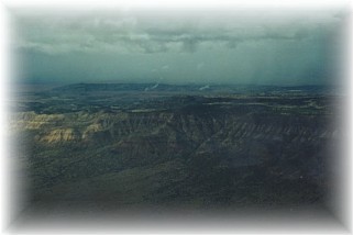
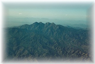
departed for our next, and likely our last, stop of the day. Soon after departing Liberal KS and passing over Dalhart TX, strange gray shapes began to appear on our windscreens. The southeastern edge of the Rocky Mountains began to take shape on the horizon. For flatlanders that have never seen mountains up close in a small airplane, these sentinels can be just a tad intimidating. We proceeded at 10,500’ MSL and 120 KTS ground speed and warily tracked these strange gray shapes as they grew bigger and more onerous. By now, we were not having any luck finding smooth air. The terrain was more rugged and that conspired with the surface winds to create strong updrafts and downdrafts. As we rounded a tall mesa south of Dalhart and turned toward Las Vegas, NM, the clouds started to force us lower. We managed to stay 3000’ AGL as droplets of water appeared on the windscreen. We did some dodging of local rain showers and we flew for a while in some light rain. That was enough to prove to me that my RV-6 was not waterproof. My son turned around to find water being pushed into the baggage area from underneath the sliding canopy skirt. Clothes, cameras, and carpet were damp. Just about that time, a big, gray, and partially obscured mountain appeared in our flight path. It was a 9,000’ peak just east of Albuquerque up on the Sandia plateau near Golden, NM. That’s when I called Glen on the radio and said I’d had enough for one day. He agreed as we both simultaneously punched the “nearest” button on our GPS. Up popped the Sandia East Airpark (1N1) and off we headed.
I awoke from a fitful night of sleep to the sound of rain drops plunking down on the cars in the parking lot outside my room. I hit the Weather Channel and found that today was going to be much like the last few days in New Mexico, damp and windy. A peek outside to the west confirmed that the Weather Channel knew what they were talking about. Low clouds and obscured mountains were on tap for the morning, but some clearing was anticipated in the early afternoon. We took our time getting ready and finally loaded up and headed back to Sandia around 11:00 am. We stopped at Ken’s lovely southwestern style home to visit. We spent the next hour or so answering Ken’s questions and offering him a few building tips. I even turned him on to the RV-List. Pretty soon Bob stopped by as we discussed our travel options for the day. I began to prepare my son for the possibility of having to turn around and head somewhere else, possibly the Southeast Regional EAA Fly-in in Evergreen, AL. Given my time constraints, I needed to make a decision by 2:00 pm to head one way or the other.
Our hosts suggested that we take a peek over the Sandia Crest to see if the valley was passable. They suggested that we head south to Alexander (E80) in Belen, NM and if the valley looked good, make a run westward. This would also give us the option of swinging south around the tall stuff and into Tucson, AZ if the ceilings didn’t allow a more direct route. St. John’s was reporting clear conditions, but very windy. While I went down to Dennis’ house to prep my airplane, Glen took Ken up for a ride in his RV-6 and to take a peak to the west. He returned 10 minutes later to report that there was space between the clouds and the crest and that the valley looked clear beyond. With that, we made the decision to give it a try. We fueled up our birds with 20.7 gallons at $ 2.34/gallon to cover the previous evening’s 2.7 hour leg from Kansas. We thanked our hosts for their warm and generous hospitality and took off. And off. And off. At 6500’ we used almost all of the mile long runway to get airborne. Once we finally tugged our fat butts into the air, we turned southwest and plunged over the Sandia Crest towards Belen. We were very happy with the relatively calm air and 4000’ ceilings. Visibility was greater than 10 miles so we could see and navigate around the patchy showers. Once over Belen, we turned west on a “relatively” direct route to St. Johns. I say relatively because they’re are more than a few peaks to be navigated around. We saw some spectacular scenery as we made our way west, flying up valleys and around brightly colored and majestic buttes. As we neared the high plain that holds St. Johns, the clouds dissipated. Unfortunately, the winds did just the opposite. Our ground speed slowed to a pedestrian-like 115 KTS. The winds were now 40 KTS and no amount of altitude was going to save us from their punishment. We tried 12,500’ MSL but no joy. Since we didn’t carry bottled oxygen, we were out of options. We passed St. Johns and I had thoughts of landing, but decided to press on. After about another 10 minutes on the roller coaster, I was regretting my inaction. Just then, an airport appeared in my windscreen amid the high pine forests of eastern Arizona. It was Show Low (SOW). Glen and I agreed that a stop was in order as both of his passengers were suffering. We called on the UNICOM and were promptly informed that runway 21 was closed and we’d have to use 27. Winds were 19 to 21 at 45 KTS. A quick computation in my mind determined that we’d have a crosswind component of approximately 30 KTS!!. My downwind crab was so severe that I had to look behind me to see the field. Glen made his approach first. As Glen was on final, the UNICOM folks, apparently concerned with our safety, warned us about severe terrain-induced updrafts off the approach end of the runway. I was concentrating on my approach when I heard Glen say “Randy, that crosswind is brutal”. I used about a 45 degree crab and tried to stay aligned with the runway. Near the ground, I pushed in full rudder deflection, planted the mains on the asphalt, and hit the breaks hard. Fortunately, my forward speed at touchdown was only in the neighborhood of 30 MPH to 40 MPH. I actually made a decent touchdown. Now the problem was rollout and taxi. My main tires were actually skidding sideways across the runway as I taxied. I slowed to a crawl and taxied in to join Glen on the ramp. After shutdown, the wind was buffeting my wings to the point where the airplane was hopping and skipping backwards off the ramp. An alert ground crew member pulled up in a pick-up truck to block the wind so our birds wouldn’t become airborne unless we intended them. The folks at Show Low couldn’t have been any nicer. I think they were surprised that we were able to get down without crashing. (I was somewhat surprised myself!) After letting our stomachs rest for an hour, we made plans for our final push into Phoenix. The first order of business was getting out of Show Low in one piece. I knew that I didn’t have enough rudder authority to hold my airplane on a takeoff roll on 27. The airport supervisor, a fellow pilot, was very sympathetic. No need to describe the ground handling difference between a tail dragger and a nose dragger to him. He suggested to us that we use the closed runway, 21, to depart. The runway had just been resurfaced and it was closed only because the painter hadn’t made it out yet. He made a call to the airport manager and over he motored in his truck. After verdant pleas on our part, he agreed to “go to lunch”, and if someone just happened to use a closed runway, well……… We thanked everyone and taxied out. The supervisor removed the temporary barricades blocking the runway and bid us good luck. We hopped off the deck in about 400 feet and climbed into the western sun. This time, we were able to find somewhat stable air at 12,500’ MSL. I thanked God for the good fortune and dialed in Roosevelt Dam as my next checkpoint. In less than an hour, we were letting down into Phoenix airspace just south of the Four Peaks area. I bid Glen goodbye as he headed to the west side of Phoenix to meet up with relatives. I made the transition over the Superstition Mall and called the tower at Gateway. We entered the pattern and made a smooth landing on 30C. We followed the man on the scooter and before long, we were shutting down on the show plane line. We had made it!!! We tended to the airplane, registered, and secured things for the night. We fueled up to avoid tomorrow’s rush. We took on 20.7 gallons at $2.37/gallon. Our last leg had lasted 3.4 hours, the longest of the trip. In two days, we had flown 1290 nautical miles in 11.9 flight hours, and burned a total of 91.5 gallons for an average burn of 7.7 gallons/hour.
Up to this point, N417G had performed flawlessly. Too bad the same couldn’t be said for the shuttle service. We had to wait 2 ½ hours for a shuttle to arrive. We tried calling five different cab companies but they wouldn’t come out. Turns out it took us longer to travel the 10 miles to our hotel than it did for us to fly in from New Mexico. We didn’t let it spoil the day though as we enjoyed a wonderful salmon dinner at the Sheraton and bedded down for a much needed and deserved rest. |
||
|
"Destiny
is not a matter of chance, it is a matter of choice; it is not a |